 Maps are our way of not only finding our path but also inventing it. And the push and pull between invention and reality is a revelation at the Rosenbach Museum and Library, “You Are Here: Maps and the Invention of Place,” through July.
Consulting Curator Michelle Schmitt writes in her introduction to the show: “The maps in this exhibition will not give you good directions, but they will tell you good stories.”
The first map, “Carte de L’Amerique et de Mers Voisines,” which is in the reception area, sets the tone. The 1763 document over and over describes (in French) “here, perhaps, is…” and then a name of some unfamiliar land or sea, like the “Sea of the West” or how about “Queivira and Teguayo”? Right away, the map lets you know that maps are not really factual (although I do suspect all of us learned, somewhere along the line, that the Mercator projection and any other map projection is a compromise, a series of choices to compensate for the flat surface that’s describing an idiosyncratic, nearly spherical shape). The author of this map knew only so much. The rest was conjecture.
Inside the show, many of the maps serve as documents of exploration and American expansion, embellished with flora and fauna of the new territories. One example, is a horizontal journey spread in seven maps across a wall. They meticulously note what and who are out there, including which Native American tribes are where (not for long, I thought), which animals along with which mountains and rivers–a sort of guide for survival in the newly charted terror-tories.
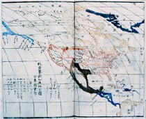 A Japanese map of Tokyo from the era of Perry’s visit to Japan, turns our Western conventions of NSEW upside down, literally. The map has no right side up, but allows orientation from any position (image right, a more familiarly oriented Japanese map of North America).
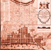
But a lot of the show stays close to home. There are a couple of swell maps of Philadelphia–one with two Second Streets, for example, one near the Schuylkill, the other where it should be, near the Delaware (image top). The map shows that the city population settled near the rivers and then expanded toward the middle of town. The importance of the rivers is clear from their dramatic–and fanciful presentation. Another Philadelphia map names Sansom Street as Broad Street, another reminder that names are not the thing itself.
An early Dutch map of North America serves as a reminder that an image of a place is also not the thing itself. The map is so confused that the land’s shape as we now know it is unintelligible.
An early map from Julius Solinis showing Asia is a thing of beauty as well as information, the rolling seas filled with sea life and dangers only imagined by the mapmaker.
Among my favorites were some small maps by George Washington of his estate along the Potomac. Apparently, Washington was a surveyor as well as a general, statesman and president, and the maps served to humanize him to me, a man proud of what he owned and careful in his ink drawings of the property.
By the way, if you’re more observant than I am, you will notice that beneath the map of Capt. Cook’s explorations, some magnifiers hang on the wall. Grab one before you begin your own exploration of the show.
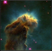 As I wandered, NASA’s dramatic cloudy columns of nebulae in space came to mind. These breathtaking photographs of the birthplace of stars that ran in the newspaper as fact are also fictionalized, the colors coming from some scientist’s desire to make a composite, computer-mediated photograph have some zing.
And it’s at this nexus that I was forced to think about Matthew Ritchie (see posts here and here), who said he too was impressed and inspired by these stunning images from outer space. Ritchie’s imagined charts of the universe at the Fabric Workshop, with warnings not to cross this barricade and funny directional signs showing (not!) which way north is, also do not give you good directions. The pieces create a physical sense of space and restriction and an unfamiliar land, but I’m really not so clear that he’s telling as good–or as coherent and clear–a story as do these maps from the Rosenbach Collection.
But both exhibits serve as reminders that no matter where we stand on the map of the universe, we’re standing on shaky ground.


